


BOZEMAN, Mont., February 6, 2017 – Hit or miss may be the best way to describe this winter in terms of precipitation. October and November brought well above average precipitation across Montana, while November and January were well below average with regards to mountain and valley precipitation. Two storm systems brought the bulk of the snowfall during the month, and did increase the snowpack, but not enough snow fell during these events to keep the basin snowpack percentages from falling, according to snow survey data collected by the USDA Natural Resources Conservation Service (NRCS).
Again this month, significant moisture stayed just south of most of the
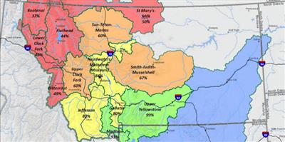
The lack of additional snowfall during the month in some northwest and northern basins, in addition to central basins east of the Divide, has dropped the basin snowpack totals from January 1, while some river basins along the southern border saw small increases through the month. Northern river basins received 35 to 65{73205e5fd8edf14435f3e2e65a2beea89873ca1d4142610a26265edfe9982562} of average precipitation at mountain SNOTEL locations for the month, while southern basins received 80 to 131{73205e5fd8edf14435f3e2e65a2beea89873ca1d4142610a26265edfe9982562}.
Most river basins are well below normal for February 1, except the Upper Yellowstone which remains slightly above normal for this date. Compared to last year, most basins have snowpack totals for February 1 that are lower than last year at this time. The Upper Yellowstone and Sun-Teton-Marias river basins have slightly higher snowpack totals, and the Lower Yellowstone in Wyoming is well above last year on February 1.
“Fortunately, as February began, a return to more favorable storm patterns brought snow to the state,” said Lucas Zukiewicz, NRCS hydrologist. Looking ahead, he said February typically is one of the drier months with regards to mountain snowfall across the state. Northwest river basins are generally favored with early winter precipitation, while basins east of the Divide are favored during the spring months. “This has been anything but a typical La Nina winter so far, and anything can happen in the coming months,” Zukiewicz said.
By February 1, 55{73205e5fd8edf14435f3e2e65a2beea89873ca1d4142610a26265edfe9982562} to 65{73205e5fd8edf14435f3e2e65a2beea89873ca1d4142610a26265edfe9982562} of Montana’s annual peak snowpack has typically accumulated. “Given that snowpack totals are below normal in most basins, above average snowfall during the rest of the winter and through the spring will be needed to expect average water supply this summer,” Zukiewicz said.
Monthly Water Supply Outlook Reports can be found here after the 5th business day of the month:
http://www.nrcs.usda.gov/wps/portal/nrcs/main/mt/snow/waterproducts/basin/.
Source: Montana NRCS
